Category:Unidentified transport infrastructure
Jump to navigation
Jump to search
Subcategories
This category has only the following subcategory.
Media in category "Unidentified transport infrastructure"
The following 60 files are in this category, out of 60 total.
-
 Accmortels.svg 326 × 292; 21 KB
-
 Alignement bundeling.png 953 × 580; 24 KB
-
 Alignement voet- en topboog.png 1,501 × 371; 19 KB
-
 Alignement voetboog.png 1,060 × 350; 10 KB
-
 Bronbemalingsbuizen en watermeter.jpg 1,704 × 2,272; 1.35 MB
-
 Bronbemalingsinstallatie.jpg 2,025 × 1,320; 1,013 KB
-
 Citystreet.png 774 × 336; 666 bytes
-
 Citystreet.svg 776 × 339; 8 KB
-
 Corridor Capacity and Infrastructure Costs de.svg 1,241 × 1,246; 4.94 MB
-
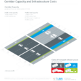 Corridor Capacity and Infrastructure Costs.png 4,141 × 4,159; 818 KB
-
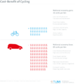 Cost-Benefit of Cycling.png 3,718 × 4,158; 290 KB
-
 Coupe chaussee.png 470 × 330; 7 KB
-
 Courbe en C2.svg 404 × 366; 195 KB
-
 Courbe à sommet.svg 292 × 396; 188 KB
-
 Courbe-en-ove.png 370 × 369; 8 KB
-
 Courbe-en-S.png 456 × 321; 8 KB
-
 Debat public rer e ouest mantes.JPG 2,592 × 1,936; 1.51 MB
-
 Dwanghoogte.png 1,229 × 630; 36 KB
-
 FIN 1979 MiNr0849 pm B002.jpg 846 × 612; 210 KB
-
 Haarlemmermeer.gif 190 × 130; 2 KB
-
 Halfklaverblad.gif 190 × 160; 2 KB
-
 Karte 1713 Trendelburg.jpg 945 × 1,520; 529 KB
-
 Lat Patriarchat Stempel Pilgerpass.jpg 1,010 × 768; 526 KB
-
 Matériel GARBARINI STC.JPG 1,600 × 1,200; 311 KB
-
 Metro Expo Line Colorado.jpg 800 × 700; 178 KB
-
 Mischungsprinzip.jpg 642 × 503; 62 KB
-
Modelling-Population-Dynamics-in-Realistic-Landscapes-with-Linear-Elements-A-Mechanistic-pone.0151217.s007.ogv 6.0 s, 1,400 × 1,000; 1.55 MB
-
Modelling-Population-Dynamics-in-Realistic-Landscapes-with-Linear-Elements-A-Mechanistic-pone.0151217.s008.ogv 6.0 s, 1,400 × 1,000; 277 KB
-
 Monti di lego.JPG 1,600 × 1,200; 681 KB
-
 Nasyp.gif 968 × 295; 5 KB
-
 Networks by flexibility.jpg 872 × 539; 102 KB
-
-
 Odrez.gif 963 × 243; 5 KB
-
 Ontvlechting weefvak.svg 482 × 793; 7 KB
-
 Panneau tournant.svg 1,052 × 744; 27 KB
-
 Rakennusvirasto infotaulu.jpg 1,833 × 1,837; 394 KB
-
Revisiting-Street-Intersections-Using-Slot-Based-Systems-pone.0149607.s002.ogv 1 min 26 s, 872 × 480; 12.03 MB
-
 Road stub mini pictogram.png 39 × 26; 2 KB
-
 SATProjectlogo.jpg 177 × 115; 23 KB
-
 Schéma-de-détermination-structure-de-chaussée.svg 1,135 × 807; 177 KB
-
 Seawalls.jpg 600 × 214; 22 KB
-
 Signal-ships.jpg 1,936 × 1,288; 929 KB
-
 Structure-de-chaussée-1.svg 300 × 275; 35 KB
-
 Structure-de-chaussée-2.svg 299 × 276; 26 KB
-
 Suicide lane.png 537 × 188; 422 bytes
-
 Suicide lane.svg 537 × 188; 9 KB
-
 Top 21 passenger air routes.PNG 1,357 × 628; 56 KB
-
 Transport - Circumferential.jpg 502 × 514; 13 KB
-
 Transport - Loop.jpg 326 × 312; 6 KB
-
 Transport - Radial.jpg 503 × 517; 10 KB
-
 Transport CBD Direct.jpg 874 × 801; 33 KB
-
 Transport Feeder.jpg 891 × 799; 54 KB
-
 Tre corsie alternate.svg 550 × 200; 1 KB
-
 Tre corsie promiscua.svg 550 × 200; 1 KB
-
 Typical signal box layout.svg 980 × 319; 24 KB
-
 Vluchtstrook met dode egel.jpeg 307 × 240; 10 KB
-
 Weefvak.jpg 188 × 324; 13 KB
-
 Zarez.gif 937 × 224; 5 KB
-
 Zone de sécurité4.svg 554 × 251; 504 KB
-
 Zuigbuis.jpg 2,260 × 1,100; 817 KB


